


Green River Area Development District (Northeast)--Daviess & Hancock Counties PUMA, Kentucky
About
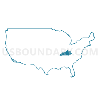
Outline
--Daviess+%26+Hancock+Counties+PUMA%2c+Kentucky_A280.png)
Summary
| Unique Area Identifier | 192966 |
| Name | Green River Area Development District (Northeast)--Daviess & Hancock Counties PUMA |
| State | Kentucky |
| Area (square miles) | 675.46 |
| Land Area (square miles) | 646.00 |
| Water Area (square miles) | 29.46 |
| % of Land Area | 95.64 |
| % of Water Area | 4.36 |
| Latitude of the Internal Point | 37.76562850 |
| Longtitude of the Internal Point | -86.99709720 |
Maps
--Daviess+%26+Hancock+Counties+PUMA in Kentucky.png)
Graphs
Select a template below for downloading or customizing gragh for Green River Area Development District (Northeast)--Daviess & Hancock Counties PUMA, Kentucky
--Daviess+%26+Hancock+Counties+PUMA%2c+Kentucky_T0.png)
--Daviess+%26+Hancock+Counties+PUMA%2c+Kentucky_T1.png)
--Daviess+%26+Hancock+Counties+PUMA%2c+Kentucky_T2.png)
--Daviess+%26+Hancock+Counties+PUMA%2c+Kentucky_T3.png)
--Daviess+%26+Hancock+Counties+PUMA%2c+Kentucky_T4.png)
--Daviess+%26+Hancock+Counties+PUMA%2c+Kentucky_T5.png)
--Daviess+%26+Hancock+Counties+PUMA%2c+Kentucky_T6.png)
--Daviess+%26+Hancock+Counties+PUMA%2c+Kentucky_T7.png)
--Daviess+%26+Hancock+Counties+PUMA%2c+Kentucky.png)
Neighbors
Neighoring Public Use Microdata Area (by Name) Neighboring Public Use Microdata Area on the Map
- Dubois, Knox, Spencer, Perry, Pike & Crawford Counties PUMA, IN
- Green River Area Development District (Southwest) PUMA, KY
- Lincoln Trail Area Development District (West) PUMA, KY
- Warrick, Gibson & Posey Counties PUMA, IN
Top 10 Neighboring County (by Population) Neighboring County on the Map
- Daviess County, KY (96,656)
- Warrick County, IN (59,689)
- Henderson County, KY (46,250)
- Ohio County, KY (23,842)
- Spencer County, IN (20,952)
- Breckinridge County, KY (20,059)
- Perry County, IN (19,338)
- McLean County, KY (9,531)
- Hancock County, KY (8,565)
Top 10 Neighboring County Subdivision (by Population) Neighboring County Subdivision on the Map
- Owensboro CCD, Daviess County, KY (45,103)
- Whitesville-Philpot CCD, Daviess County, KY (25,918)
- Utica-Stanley CCD, Daviess County, KY (25,635)
- Spottsville CCD, Henderson County, KY (12,624)
- Troy township, Perry County, IN (11,965)
- Ohio township, Spencer County, IN (5,306)
- Hebbardsville-Robards CCD, Henderson County, KY (4,479)
- Heflin-Beda CCD, Ohio County, KY (3,735)
- Lewisport CCD, Hancock County, KY (3,471)
- Calhoun CCD, McLean County, KY (3,418)
Top 10 Neighboring Place (by Population) Neighboring Place on the Map
- Owensboro city, KY (57,265)
- Tell City city, IN (7,272)
- Rockport city, IN (2,270)
- Lewisport city, KY (1,670)
- Cannelton city, IN (1,563)
- Masonville CDP, KY (1,014)
- Hawesville city, KY (945)
- Whitesville city, KY (552)
- Maceo CDP, KY (413)
Top 10 Neighboring Unified School District (by Population) Neighboring Unified School District on the Map
- Daviess County School District, KY (67,652)
- Warrick County School Corporation, IN (59,689)
- Henderson County School District, KY (46,250)
- Owensboro Independent School District, KY (29,004)
- Ohio County School District, KY (23,842)
- Breckinridge County School District, KY (18,642)
- North Spencer County School Corporation, IN (12,043)
- Tell City-Troy Township School Corporation, IN (10,417)
- McLean County School District, KY (9,531)
- South Spencer County School Corporation, IN (8,909)
Top 10 Neighboring State Legislative District Lower Chamber (by Population) Neighboring State Legislative District Lower Chamber on the Map
- State House District 78, IN (77,639)
- State House District 74, IN (61,219)
- State House District 14, KY (45,708)
- State House District 18, KY (43,650)
- State House District 13, KY (42,376)
- State House District 7, KY (39,972)
- State House District 12, KY (38,045)
Top 10 Neighboring State Legislative District Upper Chamber (by Population) Neighboring State Legislative District Upper Chamber on the Map
- State Senate District 50, IN (139,117)
- State Senate District 47, IN (128,339)
- State Senate District 5, KY (115,364)
- State Senate District 4, KY (106,696)
- State Senate District 8, KY (106,187)
- State Senate District 6, KY (102,261)
Top 10 Neighboring 111th Congressional District (by Population) Neighboring 111th Congressional District on the Map
- Congressional District 2, KY (760,032)
- Congressional District 9, IN (729,076)
- Congressional District 8, IN (694,398)
- Congressional District 1, KY (686,989)
Top 10 Neighboring Census Tract (by Population) Neighboring Census Tract on the Map
- Census Tract 4, Daviess County, KY (7,401)
- Census Tract 305, Warrick County, IN (7,204)
- Census Tract 207.02, Henderson County, KY (6,633)
- Census Tract 18, Daviess County, KY (6,244)
- Census Tract 17.01, Daviess County, KY (5,935)
- Census Tract 207.01, Henderson County, KY (5,908)
- Census Tract 13, Daviess County, KY (5,881)
- Census Tract 6, Daviess County, KY (5,434)
- Census Tract 14.01, Daviess County, KY (5,298)
- Census Tract 9, Daviess County, KY (5,124)
Top 10 Neighboring 5-Digit ZIP Code Tabulation Area (by Population) Neighboring 5-Digit ZIP Code Tabulation Area on the Map
- 42301, KY (42,440)
- 42303, KY (38,909)
- 42420, KY (38,192)
- 47630, IN (34,423)
- 47586, IN (10,932)
- 42347, KY (6,152)
- 42366, KY (5,863)
- 42376, KY (5,799)
- 47635, IN (5,671)
- 42348, KY (4,810)